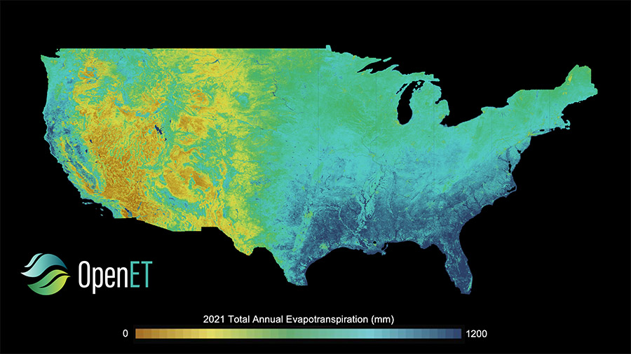
Photo of Erik overlooking the canyon at Zion National Park on a snowy day.

Meet Erik Henzl

Erik Henzl is a Staff Research Scientist and environmental economist who joined DRI in January 2025. Based at DRI’s Reno campus, he is currently focused on estimating the water and energy required to support Nevada’s rapidly expanding data centers now and into the future. In the following interview, he shares his passion for learning as a vocation and how his research will help Nevada navigate its growing role in the digital world.

Arial image of a river running through a canyon between mountains with pine trees and scrubs.

Spring Runoff is Older Than You Think

DRI’s Rosemary Carroll, Research Professor of Hydrology, co-authored a new study that found spring runoff in mountains across the Western U.S. is much older than previously known. Using advanced dating techniques, the research discovered that melting mountain snowpacks first replenish groundwater reserves before filling springs several years later. This means that the water relied on by communities across the West takes over five years from snowflake to streamflow. The research has implications for water management and our understanding of the changing dynamics of water availability.

A barn in a wooded area with pine trees with snow falling and on the ground.

Blurring the Line Between Rain and Snow: The Limits of Meteorological Classification

A new study published in Nature Communications utilizes insights gleaned from DRI’s Mountain Rain or Snow project to evaluate why traditional weather forecasting struggles to identify the rain/snow transition line. The research was possible because thousands of community members across the U.S. contributed more than 40 thousand observations of the type of precipitation falling at their location.

A satellite and Hydrosat Logo appear over a background of a thermal map.

Measuring Colorado River Evaporation from Reservoirs

DRI is advancing water management in the Colorado River basin with support from the National Science Foundation's Southwest Sustainability Innovation Engine (SWSIE) and the Governor's Office of Economic Development. Partnering with Hydrosat, DRI uses high-resolution satellite thermal imaging to enhance evaporation estimates from key reservoirs, ensuring better resource planning amidst drought and population growth.

Map showing OpenET data explorer field view.

A New, Rigorous Assessment of OpenET Accuracy for Supporting Satellite-Based Water Management 

A new study offers a comprehensive multi-model, large-scale accuracy assessment of an operational satellite-based data system to compute evapotranspiration. The researchers found that OpenET data has high accuracy for assessing evapotranspiration in agricultural settings, particularly for annual crops like wheat, corn, soy, and rice.