Groundwater Dependent Ecosystem Assessments
Project Description
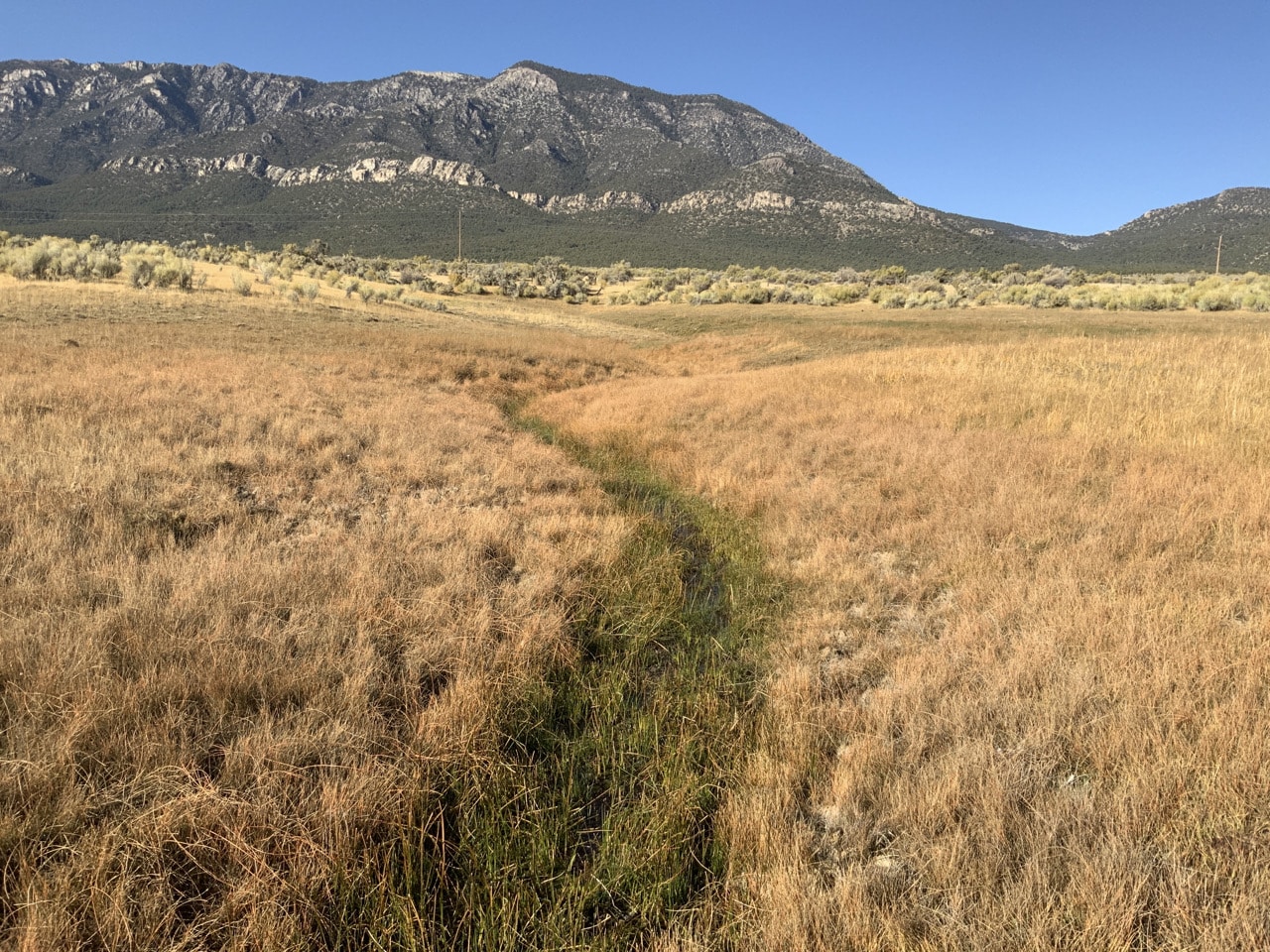
Groundwater supports a variety of ecosystems in Nevada and the Great Basin, including springs, rivers, lakes, meadows, and wetlands, as well as trees and shrubs that tap into groundwater through deep roots (called phreatophytes). Many of these groundwater dependent ecosystems (GDEs) have small footprints on the landscape, but outsize ecological, economical, and cultural importance — they provide water storage and purification, store carbon, provide recreational and economic benefits, many of them are considered sacred to indigenous peoples, and they provide habitats to a wealth of species, including many rare and endemics species that are found only in this region. As water demands for agriculture, mining, energy development, and potable water uses continue to increase, understanding the potential impacts of groundwater withdrawals on these ecosystems can assist efforts to sustainably manage limited water resources to meet economic and livelihood, wildlife habitat, recreation and other needs. Furthermore, understanding the influence of variability in climatic conditions on groundwater dependent vegetation will enhance our ability to better tease apart effects of climate from those associated with water management.
The DRI studies highlighted below seek to enhance this understanding by assessing historical patterns of vegetation variability and trends in relation to climate and management using 35+ years of Landsat satellite imagery, climate data, groundwater levels, unmanned aircraft systems (UAS), and field surveys for selected areas across the Great Basin. Reports and all data compiled for each of these studies are available below for download.
CONTACT
Christine Albano, PhD
Christine.Albano@www-dev.dri.edu
Blake Minor, MS
Blake.Minor@www-dev.dri.edu
Justin Huntington, PhD
Justin.Huntington@www-dev.dri.edu
LOCATION
Desert Research Institute
2215 Raggio Parkway
Reno, NV 89512
DIVISION
Hydrologic Sciences


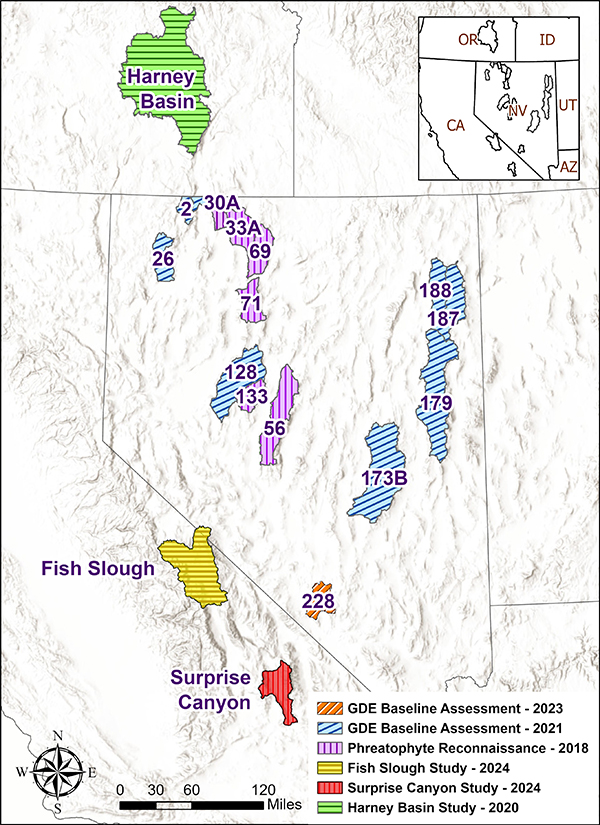
Surprise Canyon, Death Valley NP Study-2024
A Remote Sensing Investigation of Surprise Canyon Creek Wild and Scenic River
Objectives: 1) Develop a first approximation of the water required to sustain the Surprise Canyon Creek Wild and Scenic River corridor (WSRC) in its “free-flowing condition”, 2) provide a baseline against which future changes in riparian and other groundwater dependent vegetation can be compared as guidance for future monitoring and management decisions
Key Findings:
- Most riparian and other groundwater-dependent ecosystems (GDEs) show positive trends in vegetation vigor, with the greatest increases observed along the Surprise Canyon Creek Wild and Scenic River corridor (WSRC) and valley floor mesquite bosque areas. Vegetation vigor in upland areas is trending more positively than in GDE areas.
- Varying degrees of groundwater dependence are observed at different sites along the river corridor, as evidenced by differing sensitivities of vegetation vigor to interannual climate variability. Estimated median annual water use by vegetation within the WSRC over the 1985-2021 period of record amounts to 99 acre-ft in the NPS portion and 68 acre-ft in the BLM portion, with 55% and 70% of this provided by groundwater, respectively.
- Estimated median annual water use within the mesquite bosque amounts to 1684 acre-ft, with 60% of this provided by groundwater.
- The coincidence of the official road closure (2001), ongoing tamarisk removal on BLM lands (2007-2010), and decreased climate variability after 2008 confounds efforts to identify causal factors of changes in vegetation vigor, though there is reasonable evidence to suggest that increases in vigor in the Chris Wicht reach may be due to removal of a water diversion in 2006.
Download the report and associated datasets here:
- Report
- Datasets
Fish Slough, Owens Valley, CA Study-2024
Assessment of Potential Drivers of Surface and Groundwater Declines at Fish Slough, Owens Valley, CA
Objective: Compile and analyze climate, remote sensing, groundwater pumping, and observational datasets to assess how climate and groundwater pumping influence surface water flows, groundwater levels, and vegetation conditions at Fish Slough
Key Findings:
- While Fish Slough spring flows and groundwater levels are influenced by climate and catchment recharge within the same year, these effects are masked by the overall declines in spring flows and groundwater levels due to groundwater pumping.
- Estimated groundwater withdrawals in the Tri-Valley area had the strongest correspondence with declining groundwater levels and spring flows at the Northeast Spring at Fish Slough. Effects are observed within the same year.
- Available data suggests that pumping in the Laws wellfield is not influencing rates of flow and water level declines in Fish Slough, nor is there strong evidence indicating that Fish Lake Valley pumping is influential.
- Northeast Spring flows strongly influence a large proportion of the Slough area. Declines in flow have resulted in increases in vegetation and decreases in surface water in the wettest parts of the Slough.
Download the report and associated datasets here:
- Report
- Datasets
GDE Baseline Assessment - 2021-2023
Baseline Assessment of Groundwater Dependent Vegetation in relation to Climate and Groundwater Levels in select Hydrographic Basins of Nevada
Objective: To establish a baseline for monitoring and assessing the potential impacts of groundwater developments on GDEs in selected hydrographic basins of Nevada by quantifying the current status and historical trends in the condition of groundwater dependent vegetation relative to trends in both climate and groundwater levels. Analyses were completed for Pueblo, Continental Lake, Mud Meadow, Dixie, Railroad-North, Steptoe, Goshute, and Independence Valleys in Nevada in 2021. An additional analysis of Oasis Valley was completed in 2023.
Key Findings:
- In several valleys, the areal extents of groundwater dependent vegetation (phreatophyte areas) were substantially smaller than was estimated historically, suggesting that either the historical extents were overestimated or that there have been substantial losses of groundwater dependent species due to lowered groundwater levels. These differences are important and merit further investigation, as real losses in groundwater dependent vegetation indicate large-scale ecological change, while historical overestimation of the phreatophyte area may suggest historical overestimation of the groundwater discharge, which has served as the basis for determining the perennial yield and groundwater appropriations for each valley.
- Analysis of Landsat satellite data over 35 years revealed that vegetation outside the phreatophyte areas – especially forest and woodland vegetation was, on average, trending more positively than phreatophyte area vegetation, which tended to have only slightly positive to slightly negative trends. Areas classified as riparian, wetland, and low-intensity agricultural vegetation consistently had larger magnitude trends and tended to have a larger proportion of negative trends relative to dryland vegetation types. The trends observed in this study deserve careful consideration and future research to better isolate their causal factors.
- Permitted groundwater rights are higher than the current estimated perennial yield in five of the nine basins assessed. Lack of consistent and long-term groundwater data was the most limiting factor in this study. Given the available data, over 25% of wells in each of five basins had statistically significant declines in groundwater levels. The largest declines in groundwater levels were most often observed in direct association with irrigated agriculture (up to 10’s of feet over 35 years) and mining activities (up to 100s of feet).
- Substantial human impacts were documented at all GDE sites that were visited in the field, but trends in vegetation over time varied from negative to neutral to positive. In most cases, there was insufficient groundwater levels data available to quantify groundwater-vegetation relations. This is an important data gap that will be essential to fill in order to understand the effects of water development on these ecosystems.
Download the report and associated datasets here:
- Report (Download PDF)
- Report – Oasis Valley (Download PDF)
- Datasets
Harney Basin Study – 2020
Status and Trends of Groundwater Dependent Vegetation in Relation to Climate and Shallow Groundwater in the Harney Basin, Oregon
Objective: To increase understanding of relations between variations in climate, shallow groundwater, and groundwater dependent vegetation in the Harney Basin, OR.
Key Findings:
- Trend analyses of groundwater levels indicate widespread declines in groundwater levels across the basin; in most cases these declines were determined to be occurring independently of antecedent climate conditions.
- Substantial changes in surface water extent, vegetation vigor, and land use, indicated by the Landsat Normalized Difference Vegetation Index (NDVI), were evident over the course of the 35-year study period, with positive trends in NDVI indicating lake level declines since the mid-1980’s and subsequent encroachment by sparse vegetation as well as increases in irrigated cropland. Negative trends in vegetation vigor were most prominent in riparian and wetland vegetation types and low-intensity agricultural lands used as pasture and/or hayfields.
- Site-specific analyses of field survey and remote sensing data identified transitions from mesic (i.e., riparian and wetland) to dryland vegetation along the edges of Malheur Lake in response to declining lake and shallow groundwater levels since the 1980’s. Other areas where trends in vegetation were evident have limited evidence of groundwater declines and are places where non-native plant species invasions and intensive vegetation management activities such as mowing, prescribed fire, invasive plant management, and agricultural water management are likely influencing vegetation trends.
Download the report and associated datasets here:
- Report
- Datasets
Phreatophyte Reconnaissance – 2018
Spatiotemporal Reconnaissance Investigation of Phreatophyte Vegetation Vigor for Selected Hydrographic Areas in Nevada
Objective: Identify patterns of phreatophyte vegetation vigor change through space and time and qualitatively assess relations between these changes and variability in precipitation, evaporative demand, and depth to groundwater for selected hydrographic basins where significant declines in groundwater are known to have occurred due to pumping for irrigation. Analyses were completed for Kings River, Quinn River (Orovada subarea), Upper Reese River, Paradise, Grass, and Edwards Creek Valleys in Nevada.
Key results:
- Findings from this study illustrate that phreatophyte vegetation vigor changes can be observed from Landsat satellite imagery and confirmed with field investigations.
- Groundwater levels have substantially declined over the last 50 years in many basins, and vegetation species have become less mesic from historical observations made in the 1960s and reported in USGS Reconnaissance Series Reports
- An important conclusion from this study is that while declines in vegetation vigor and localized stress and mortality was observed in areas with declining water levels, facultative phreatophyte vegetation such as greasewood persists where groundwater levels were historically at or near land surface (i.e., 0 to 30 ft) and currently exceed the typically reported range of rooting depths (~20 to 60 ft) for this species, suggesting that precipitation has been sufficient to sustain these vegetation communities over the long term.
Download the report and associated datasets here:
- Report
- Datasets