Frank McDonough is a research and forecast meteorologist who leads DRI’s cloud seeding program. His research interests span cloud physics, aviation icing forecasting, and precipitation enhancement.
In this interview, Dr. McDonough answers frequently asked questions about how cloud seeding works and what makes DRI’s program unique. This is the second in a new series of FAQ videos with DRI researchers.
If you’d like to see another faculty member highlighted in this series or have specific questions for our researchers, reach out to media@www-dev.dri.edu.
DRI: What is cloud seeding?
Cloud seeding is the only way to increase water resources in Nevada, which is the driest state in the U.S.
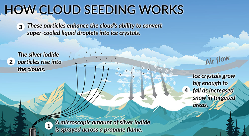
At its core level, cloud seeding is introducing a dust particle which allows an ice crystal to form. And then that ice crystal will grow into a snowflake and fall to the ground, increasing water resources and snowpack.
DRI: What are the benefits of cloud seeding?
The cost to create this water is 50 times less than what you pay when you turn on your faucet. So, the water is really cheap to produce and valuable.
The main benefit is increased water resources. But there’s also secondary benefits: it increases fisheries, it increases water resources for humans in arid climates, and is thought to be able to offset decreases in precipitation from upstream air pollution. And it can also decrease the fire danger by keeping the snowpack on the ground for a longer period of time in the spring.
DRI: How much water does your program add to the Nevada water supply each year?
The cloud seeding program in Nevada produces, on average, 18 billion gallons of water per year, which is enough water for 140,000 households’ yearly use. And then we’re also under a constant threat of increasing temperatures and more and more longer-lived droughts. So, cloud seeding gives us an opportunity to at least keep the water resources flowing as much as possible with a really, very inexpensive technology.
DRI: What makes DRI’s program unique?
DRI’s program is actually a research program. So, we study every aspect of cloud seeding from the what the dust particles are, how they create the ice, how the ice grows snowflakes, and how that snow then moves through the environment and comes down as precipitation and then validates the success of the programs.
And then we also improve the programs through feedback from the research. So, we’re always combining research with operations. And then the bigger picture stuff is that we’re also pushing the envelope of how ice actually forms in the atmosphere, which is a poorly understood topic in atmospheric science. So, we’re also trying to better understand ice production and clouds, and also the role of aerosols in production of precipitation as well.
DRI: What is DRI’s method of seeding clouds?
So, the DRI cloud seeding program is conducted from the ground using ground-based cloud seeding generators. These generators produce the dust particles that create the ice from the ground during periods when low clouds during storms are moving through the area. And these clouds also have to have the subfreezing liquid water drops in them as well.
The DRI program uses silver iodide to conduct cloud seeding. Silver iodide has been studied for over 60 years now and has been found to be safe for the environment and to not accumulate in soils and streams.
DRI: How do we know silver iodide is safe to use?
The amount of silver that’s being added by the cloud seeding program is in the parts per trillion numbers, and the background amounts of silver is in the parts per million. So, we’re talking about a million times more naturally occurring in the soil than what’s being added by the cloud seeding program. And it would take millions and millions of years for the extra silver from the cloud seeding program to actually show up in the soils.
DRI: Where does DRI cloud seed?
We run the Nevada State Cloud Seeding program. We have projects in the Eastern Sierra Nevada, we have a project in the Spring Mountains, and we have another project in the Ruby Mountains in the Humboldt Basin headwaters. And we also conduct projects in Colorado as well. In addition, our cloud seeding technology — which we’ve been working on for 60 plus years now — is the state of the art in the science, and so other programs now have started to purchase DRI’s cloud seeding equipment, and they are using that to conduct cloud seeding operations across the Western U.S. at this time.
DRI: Why do you work to supplement the snowpack rather than rainfall?
Most precipitation occurs across the Western U.S. during the winter, and the primary precipitation over mountain ranges is snowfall. So, our goal during cloud seeding operations is to create ice in clouds, and that ice forms into larger snowflakes and a snowflake comes down to the ground. So, over the project areas, the precipitation that falls during our cloud seeding projects is typically snowfall. Now, we do have some projects, we have one in the Spring Mountains where we’re actually targeting the Red Rock Canyon National Recreation Area, and there we’re primarily adding rainfall to the basin, but we’re doing it by creating ice crystals in the upper portions of the clouds, and then they fall to the ground. But using ground-based equipment, most of our activity is close to the ground. And so, most of our projects are snow enhancement projects.
DRI: Can cloud seeding be used to put out wildfires?
Cloud seeding cannot create clouds. It can only modify the cloud’s efficiency to convert small droplets and ice crystals into precipitation. So, in the summer, when the atmosphere dries out and the plants are drying out and the fire danger starts to go up, there really isn’t any way to do cloud seeding because there are no clouds. We can’t create rain from blue sky.
DRI: How do cloud seeding contributions vary from year to year?
The amount of water we add each year is variable because as I said, we can only really conduct cloud seeding when storms are moving through the area. So, it’s a function of how many storms are moving through the area and when these storms have the proper conditions for cloud seeding to occur. So, some years are better than other years. Now, we also have suspension criteria. Some winters when the snowpack gets humongous, we step down because there’s obviously no need for extra runoff. So, we suspend the project, and we have strict guidelines for when we suspend. But, on a typical winter across our Nevada project areas, we produce anywhere from 50 to 70,000-acre feet. We could produce more in the big years. And then in the lean years, the numbers are a little bit lower, maybe 40,000-acre feet, but that lean year water is much more valuable because that’s going to be a year when water resources are going to be strained. And so, the water we produce is actually even more beneficial to the project areas because it helps offset some of these drought periods.
And then in addition, if you do the cloud seeding year to year, you can sometimes bridge the drier years by seeding a wet year. Then you have less water that next year, but the cloud seeding maybe kept the reservoirs a little fuller, and then we can maybe make it through the drier periods a little more successfully with the extra water the cloud seeding produced during the wetter years, in addition to what it was able to put down during the dry year.
For more information about DRI’s cloud seeding program, visit www.dri.edu/cloud-seeding-program and Making it Snow: A Brief History and Review of the Science Behind Cloud Seeding