ARkStorm@SierraFront 2.0
Increasing Resilience to Extreme Winter Storms on the Leeward Side of the Sierra NevadaProject Description
In 2011 the USGS developed the ARkStorm scenario for the state of California. ARkStorm is a hypothetical 23-day extreme winter atmospheric river (AR) storm sequence that was created by splicing together two historical storm events from 1986 and 1969 back-to-back. ARkStorm was designed to approach – but not exceed – the precipitation that occurred during a series of storms in 1861-1862. This 1861-1862 storm series flooded the entire Central Valley of California and had far reaching effects across the Sierra Nevada and eastward.
The USGS and partners estimated the costs of property damage and business interruption of an ARkStorm-like event in present day to be on the order of $725 billion for the state of California — more than three times that of Hurricane Katrina, which devastated New Orleans in 2005. The ARkStorm project helped to bring flood risk awareness to the forefront in a region more accustomed to focusing disaster planning on drought and wildfire events.
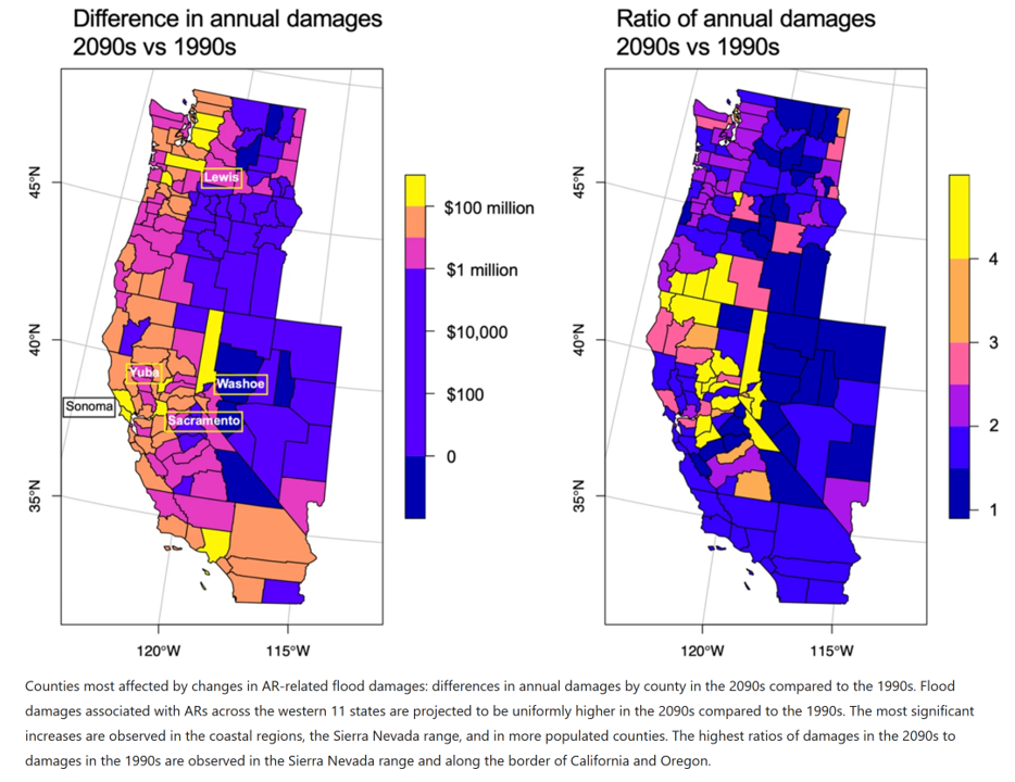
Despite being on the ‘dry’ side of the Sierra Nevada, communities within the Truckee and Carson River basins and surrounding areas are among those most affected by atmospheric river-related flood damages (Corringham 2019) and projected losses could plausibly increase four-fold by 2090 (compared to 1990 levels) due to warming climate (see figure below from Corringham et al. 2022).

ARkStorm@Tahoe 1.0
In 2013-2014, the ARkStorm scenario was downscaled to the Lake Tahoe region by DRI collaborators to specifically explore and address some of the short-and long-term impacts that are unique to relatively isolated communities surrounded by mountainous terrain and large areas of undeveloped land. Because so many stakeholders had vivid memories of storm impacts from 1997, over 300 people engaged in this effort, through a series of six discussions focused on different regions and types of impacts and a follow-up emergency response tabletop exercise.
The ARkStorm@Tahoe scenario had several benefits, including enhancing awareness of potential storm and flood risks in the region, identifying weaknesses in cross-sectoral communications that stakeholders indicated they addressed and improved upon during the extreme winter of 2017, motivating advancements in applied science aimed toward better prediction of AR precipitation and hydrologic impacts, and improving preparedness and responses (e.g., pre-positioning of equipment, staff, and fuel supplies to ensure continuity of operations during power outages in 2017).
ARkStorm 1.0 References
ARkStorm@Tahoe 1.0 References
- ARkStorm@Tahoe: Stakeholder Perspectives on Vulnerabilities and Preparedness for an Extreme Storm Event in the Greater Lake Tahoe, Reno and Carson City Region (PDF)
- Application of an extreme winter storm scenario to identify vulnerabilities, mitigation options, and science needs in the Sierra Nevada mountains, USA (PDF)
- Techniques for constructing climate scenarios for stress test applications (PDF)
ARkStorm@SierraFront 2.0
Given the more recent flood and winter weather impacts experienced in 2017 and 2023, there are new opportunities to share valuable lessons learned. These recent events, coupled with expectations of more extreme flood impacts in the future and changing risk profiles due to rapid population growth along the Sierra Front highlight the need for additional discussion on ways to increase resilience to winter storms.
DRI and partners will use a new ARkStorm 2.0 scenario to engage stakeholders in in the greater Tahoe region once again. Similar to the first ARkStorm, this new scenario is based on a series of atmospheric storms that hit the western US coastline over approximately one month. Unlike the original ARkStorm, the scenario was generated from climate model projections that simulate expected changes to storm meteorology under a warming climate.
In addition to the new ARkStorm 2.0 scenario, new models and information have been developed that allow for a more comprehensive analysis of flood risks than was possible a decade ago. The ARkStorm@SierraFront 2.0 effort will integrate stakeholder perspectives with analysis of new datasets to better understand the implications of flooding to populations and infrastructure in the region and identify ways to increase resilience to winter storms under a warming climate.
ARkStorm 2.0 References
- Climate Change is Increasing the Risk of a California Megaflood
- Incorporating Climate Data into Emergency Planning and Exercises – A Primer for Emergency Management Practitioners and Data Developers
- Using the ARkStorm Meteorology within HEC-HMS– a preliminary analysis of ARkStorm 2.0 hydrology in the Truckee, Sacramento, and San Joaquin basins
- ARkStorm 2.0 Scenario Explorer App
CONTACT
Maureen McCarthy. PhD
Maureen.McCarthy@www-dev.dri.edu
Christine Albano, PhD
Christine.Albano@www-dev.dri.edu
LOCATION
Desert Research Institute
2215 Raggio Parkway
Reno, NV 89512
DIVISIONS
Earth & Ecosystem Sciences
Hydrologic Sciences
ARkStorm SCENARIO EXPLORER
MEDIA
Studying, planning for, and warming of megastorms. Radio interview with Maureen McCarthy.
Stories of the Future: ARkStorm@SierraFront
Preparing for ‘the big one’: How computer modeling can help cities plan for massive floods
Too much of a good thing: Damaging atmospheric rivers likely to increase flood risk