DRI’s Charles Morton, Associate Research Scientist of Geography, who had a key role in the expansion of OpenET said, “Delivering wall-to-wall evapotranspiration data across the contiguous United States at the field scale is a major milestone for OpenET, and it’s exciting for us to imagine the future research and practical applications this expanded coverage will unlock.”
Read the full press release from NASA below:
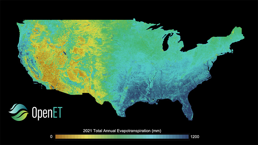
All 48 contiguous United States will now benefit from timely, high-resolution water data.
The OpenET program, a public-private collaboration led by consortium partners NASA, the U.S. Geological Survey, California State University Monterey Bay, Environmental Defense Fund, Desert Research Institute, Google Earth Engine, and HabitatSeven, provides information on evapotranspiration.
Evapotranspiration is the movement of water from the ground to the atmosphere through plants and by direct evaporation from the ground. The OpenET program serves as an important tool for water resource management, irrigation planning, drought monitoring, and fire risk evaluation.
OpenET’s Data Explorer tool originally launched in 2021, with data available for 17 western states. The Farm and Ranch Management Support (FARMS) tool, launched in early 2025, provides an easy-to-use interface designed for individual farmers and ranchers. At the time of the FARMS release, data were available for 27 states. On Dec. 15, data became available for 48 states across all tools.
Applications of OpenET include:
Water use reporting: The California Central Delta Water Agency and South Delta Water Agencyuse OpenET to support water use reporting to the state, which has led to an increase in landowner reporting and significant cost savings for farmers.
Irrigation management: From individual landowners to large companies, including Gallo and Sun Pacific Farming, OpenET helps growers of all sizes track crop water consumption to optimize irrigation, maintain or improve yields, and reduce costs.
Groundwater accounting and management: Water agencies in California and Nebraska are using OpenET in an open-source groundwater accounting platform developed by the Environmental Defense Fund and its partners, to help farmers track and manage their water budgets. Agencies in Oregon and Kansas are developing pilot projects with the accounting platform.
~ Milan Loiacono